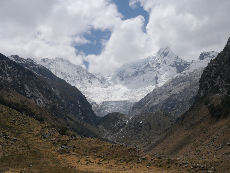
The journey from Chimbote (the last
place on the coast where I had to change buses) to Huaraz in itself was
spectacular. Near to the coast, the weather was cloudy as is typical for the
central coastal region of Peru. The resulting grey light on the dusty hills created
an unusual blend of browns, greys and blacks across the terrain. Once climbing
up onto the Andes, the skies cleared and when the bus reached the top of the
mountain pass, an incredible vista appeared as the wide spread of the
snow-capped peaks of the Cordillera Blanca were visible for the first time. My
spirits immediately lifted and, being a mountain lover, I immediately felt at
home.
 |
| Browns, Greys & Blacks Near Chimbote En-Route to Huaraz |
 |
| En-Route to Huaraz (Visible in Valley Below): The First Glimpse of the Spectacular Cordillera Blanca |
For the full complement of photos
corresponding to this blog entry, use the following link to the set of photos
in my Flickr pages:
Laguna 69: 13th August
The day excursion to Laguna 69 (in
the Llanganuco valley) is one of the most popular tourist activities in Huaraz,
but it has undeniably stunning vistas and is also a easy day´s walking to spend
a little time getting used to heights above 4,000 metres again. The only
downside to the day trip is the three hour journey each way from Huaraz to the
trailhead.
The gravel mountain road climbs from
the town of Yangay and passes by Laguna Chinancocha and Laguna Urconchocha,
which are an incredible aqua marine / turquoise colour. After starting at the
trailhead, during the walk up the valley I was flanked by the peaks of Huascarán
and Huandoy. Laguna 69 is a small lake sitting in a small plateau at 4,625
metres (15,174 feet) below the striking, almost sheer faces of Mount Chacraraju.
The richness of the blue of Laguna 69 is breathtaking.
 |
| One of the Llanganuco Lakes During the Drive to the Trailhead for the Laguna 69 Walk |
 |
| Mount Chacraraju in the Distance During Walk to Laguna 69 |
 |
| The Stunning Blue Laguna 69 with Mount Chacraraju Behind |
 |
| Returning From Laguna 69 With Views of Huascarán Sur & Huascarán Norte in the Distance |
Mount Vallunaraju (5,686 metres /
18,655 feet): 15th & 16th August
My ascent of Mount Vallunaraju at
5,686 metres (18,655 feet) was an acclimatisation climb in preparation for my
later ascents of the higher peaks of Chopicalqui and Huascarán Norte. I made
the trip with my new-found British friend Chris and our guide Manuel.
We reached the trailhead by driving
along a very bumpy dirt road. As we neared the end of the valley, the imposing
sight of Mount Ranrapalca appeared, from which a glacier spills down. The vast
ice feature ends abruptly in, what looked like from a distance, a huge near
vertical cliff of ice perhaps nearing 200 metres high. I have never seen such a
precipitous and abrupt end to a deep glacier. Higher up Mount Ranrapalca, huge
hanging glaciers lie in vast thick sheets.
 |
| The Incredible Ice Cliff at the Head of the Glacier Spilling Down from Mount Ranrapalca |
The walk up from the trailhead at
4,474 metres (14,678 feet) to the moraine camp at around 5,000 metres (16,404
feet) took around two hours carrying all the gear. The camp gave us an even
better view of Mount Ranrapalca and was a pleasant place to relax before the
night climb.
 |
| Tim at Mount Vallunaraju Moraine Camp with Mount Ranrapalca in the Distance |
We set off for Vallunaraju at around
2:30am and made the short climb across the moraine to reach the edge of the
glacier where we put on our snow and ice gear. Initial sections of the walk
were fairly uneventful – just slowly gaining height. Some ice features and
sections like ´stepping stones´ across the crystalline ice provided some
entertainment a little later. Indeed, the higher we climbed, the more that the
beautiful crystalline ice became a feature of the walk.
 |
| Just After Sunrise During Ascent of Mount Vallunaraju with Crystalline Ice in the Foreground |
After enjoying the sunrise with
views of Huaraz in the distance the way became a little steeper, finishing with
a climb to the ridge that would lead us to the summit. On this ridge was a thin
section where the crystalline ice was remarkable. The path of compacted snow
and ice created by the footsteps of numerous climbers was set deep on the
ridge. The crystalline ice that had formed either side of the route created a
´walled pathway´ that was beautiful in front of the backdrop of the peaks to
the south. After a further short climb we reached the summit at around 6:45am
and enjoyed great views – notably of the Chopicalqui and Huascarán peaks to the
north.
 |
| Incredible Crystalline Ice on Ridge Approaching Summit of Mount Vallunaraju |
 |
| Tim & Manuel on Summit of Mount Vallunaraju (Mount Chopicalqui which I climbed the following week is the mountain to the right of me with cloud on it´s summit ) |
During the descent in the morning
light we could see all the crystalline ice forms in all their glory – and there
were so many of them spread before us. We made short work of the glacier during
the on the way down. After a quick break at the moraine camp, it did not take
long to finish off the walk and reach the road to meet our transport back to
Huaraz.
 |
| A Vast Glacier Topped with Crystalline Ice on Mount Vallunaraju |
No comments:
Post a Comment