Tuesday, November 29, 2011

2011, 21st - 30th November: Punta Arenas & Puerto Williams, Chile & Ushuaia, Argentina

2011, 21st - 30th November: Punta Arenas & Puerto Williams, Chile & Ushuaia, Argentina


For a full complement of photos, follow this link to the set my Flickr account:


2011, 21st & 22nd November: Punta Arenas, Chile

Spent waiting in Punta Arenas for the (once-weekly) ferry to Puerto Williams. A chance to catch-up on my photo-uploading in the first location in 5 weeks or so with a good(ish) internet connection.


23rd & 24th November: A Voyage on Ferry Yaghan from Punta Arenas to Puerto Wiliams

This 28 hour ferry journey is a far cry from any I have taken before (such as those across the English Channel or the North and Irish Seas). The geography at this southern-most end of the continent of South America is a myriad of narrow channels, islands, islets and inlets - making for some stunning views and a very memorable voyage. The area has a rich maritime history as it was through these naval waterways that explorers such as Magellan and Cook sought passages linking the Atlantic and Pacific Oceans (until the voyages of Magellan it was not known whether such routes to the Far-East existed).

Magellan discovered the northern route (named the Magellan Straights) which lie between the mainland and the large island of Tierra del Fuego (land of the fire; so named by the first voyagers after they saw the fires of the natives that lived there). Captain Cook chartered the southern route (the Beagle Channel) which lies between Tierra del Fuego and the Chilean island of Isla Navarino.

The ferry voyage took us through the Magellan Strait, and the O´Brien, Darwin, Ballenero, Beagle, Magdelena, Cockburn, Ocasión and Brecknock channels - so the captain and crew had to keep their navigational wits about them.

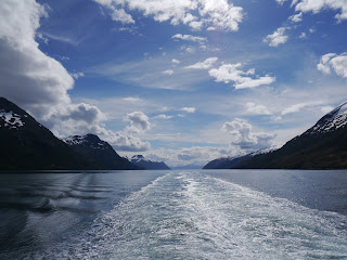
The narrow passages navigated by the ferry throughout the majority of the journey provided a constant close view of the edges of the channels formed by islets, mountain slopes, glaciers and countless small inlets. The weather was clear and windless, so for much of the journey I marveled at the views across a perfectly calm channel (like a mill pond). I was lucky to have the company of two French women (Chamille and Marie) that I met the previous week in Puerto Natales.


Early Morning View Approaching One of the Many Narrow Passages On-Route


Ferry Yaghan with a Wonderful Backdrop

I enjoyed yet more amazing Patagonian skies with vast views to the far horizon across multi-layered clouds sitting in a rich sky - a true tapestry of numerous tones of blue and white, (what creates these amazing Patagonian skies - is it the clarity of the air)?


Ah....Those Southern Patagonian Skies.....


A Glacier ´Tumbling´ Into our Seaway


25th & 26th November: Puerto Williams, Chile

Puerto Williams on the island of Isla Navarino (across the Beagle Channel from the (much larger) island of Tierra del Fuego)) is the southern-most (notable) town in the world (despite what the Argentines may claim about Ushuaia on Tierra del Fuego). As one might expect for such an out-post, there is not a lot happening in Puerto Williams, but it serves as a good base for walks around the peaks of the Dientes de Navarino (the ´Teeth of Navrino´) - so called because of the teeth like line of mountain peaks.

While there, I made a one day trek to see the peaks (one day was enough as I must say that after so much mountain trekking in Patagonia, me and (my knees in particular) feel a bit walked-out for the time being). While on my trek I was fortunate to see a condor sitting on an outcrop just 15 metres away. Throughout the remainder of the walk, I continued to see him demonstrating his effortless use of thermals.


A Condor Surveys the Valley Below
(of Valley of Rio Ukika on Isla de Navarino)


La Dientes de Navarino (The Teeth of Navarino) With Laguna el Salto Below


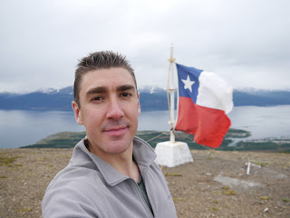
Tim in the Deep, Deep South of America: At the Mirador (View-Point) above Puerto Williams With the Beagle Channel Behind Me


27th to 30th November: Ushuaia, Argentina

The journey across the Beagle Channel from Puerto Williams (Chile) to Ushuaia (Argentina) is not easy (nor is it cheap) as there are no timetabled crossings, just fast launches (boats) or small planes which will only make the journey if there are sufficient passengers wanting to make the crossing. I elected to take the fast launch so enjoyed a rapid 75 minute boat ride.


The Fast Launch I Took from Puerto Williams to Ushuaia (Across the Beagle Channel)


I travelled to Ushuaia so that I could catch a flight to Buenos Aires where I will take a ferry across the Rio de la Plata to Uruguay. My time in Ushuaia was mainly spent planning the Uruguayan leg of my travels. I did however, make time out to join a couple of friends from the hostel to visit the maritime museum which is housed in an old prison (many of the exhibits are in the old cells). It provides a history of the early naval exploration of this area, the Yámanas (indigenous people who used to live on Tierra del Fuego), Antarctic expeditions and the prison itself.

Some great laughs were provided by some poor translations:

"He placed a plaque at Cape Horn for the survivors of the sucked ships.." I guess the ships were sucked and sucked until they sunk!

The following text may not be in error, but simply a weird quote:

"They had few choices: Brazil, Uruguay or Argentina. The choice was easy: A big country, simple settling down formalities and no need of going into the forest". From this I assume that in Uruguay and Brazil you are woken at 4am every day for your obligatory walk into the forest - either that or there are no toilets at all and one has to go behind a tree to squat!

The following is a wonderful example of Edwardian British pomposity written by Dulse in 1902. It relates to the anthropological description of the Yámana people who were documented by the likes of Darwin et al:

"They are short and ugly, figures of crooked and contracted legs in whom Darwin is thought to have found the missing link". Flip, don´t expect to get invited round to their place for tea!


Wednesday, November 23, 2011

2011, 13th - 20th November: Puerto Natales, Chile - Torres del Paine

2011, 13th - 20th November
Puerto Natales, Chile

15th - 18th November: Walking the W Circuit in The Torres del Paine National Park

For a full complement of photos, follow this link to the set my Flickr account:
 
http://www.flickr.com/photos/67212524@N04/sets/72157628103589165/


The Torres del Paine national park in Chile is famous for it´s numerous granite spire-like peaks and many beautiful valleys which are all surrounded by numerous lakes of wonderful rich blues. A popular way to see many of the key vistas is to complete "The W Circuit" - so called because the trails followed form a W shape. It is normally walked in 5 days, but I chose to do it in 4 as this was the duration of the forcasted dry weather, plus I like a tough physical challenge (nutter). All gear has to be carried if you want to do the cheaper camping option (rather than staying in the refuges) - I camped so that meant a heavy(ish) pack with the crazy amount of food I get through.

I completed the trek in mid-November which is before the peak season period from December to February. Despite this the routes were pretty busy with walkers - the trails must be overly busy during the peak months.

I walked the first day with Sergio (a Brazilian guy I met three days before on a bus to Calafate), but on the morning of Day 2 he had to head back to Puerto Natales so I made the rest of the trek alone.

Day 1: The Torres
 
The morning was occupied by getting into the park, so only a part day of walking. I walked up Valle Ascencio to set up camp in Campamento Torres. After that, a climb up to the mirador (viewing point) at Base de las Torres gave a wonderful view across a lagoon to the towering granite spires of Torre Central and Torre Norte.


The W Circuit Day 1: View from the Base de Torres


Day 2: Valle del Frances
 
This was the first of two long days. I returned down Valle Ascencio, then past Lago Nordenenskjold to the bottom of Valle del Frances. Most people then stop and camp at Campamento Italiano, but I continued and climbed up to the top of the valley as this would help to save a day - plus I could camp in the circular vista at the top of the valley at Campamento Britanico. This meant that the day ended at gone 9pm but I was able to enjoy an evening view of the 270 degree panorama from above the mirador at the top of Valle de Frances which was spectacular.


The W Circuit Day 2: Part of the Vista at the Top of Valle del Frances


The W Circuit Day 2: Tim Enjoying the Vista at the Top of Valle del Frances


Day 3: Glaciar Grey
 
The second of two long days. I returned down Valle del Frances, past Lago Skottsberg then climbed up the valley alongside Lago Grey - a sometimes frustrating day in the heat as every climb was matched with a descent, slowing progress somewhat. The closer I got to Glaciar Grey, the more icebergs were visible on Lago Grey. The whites of the icebergs were stratified by lines of electric blue. The person who named Glaciar Grey must have had bad luck with the light on the day they saw it, because I was lucky enough to enjoy its rich blue hues throughout my time there. After reaching Campamento los Guardas (which is in a fantastic location above the glacier), I set up camp then carried stove and dinner gear across to the rocks above the glacier to have a cup of tea and a hot dinner in a location with a wonderful view!


The W Circuit Day 3: The Rich Blue Glaciar Grey Meets Lago Grey


The W Circuit Day 3: A Great Spot for a Cup of Tea & a Hot Dinner!


The W Circuit Day 3: A More Civilised Version of "Brit-Abroad" - An Englishman and His Cup of Tea in a Great Location!


Day 4: The Return Leg
 
I returned back down the route alongside Glaciar Grey down to the shores of Lago Pehoe where I waited for a catamaran that took me across the lake to connect with a bus back to Puerto Natales.

2011, 11th - 12th November: El Calafate, Argentina - Glaciar Perito Mereno


2011, 11th - 12th November
El Calafate, Argentina

12th November: Glaciar Perito Mereno

For a full complement of photos, follow this link to the set my Flickr account:

http://www.flickr.com/photos/67212524@N04/sets/72157628101192847/

The rather famous Perito Mereno glacier is located near the town of El Calafate in Argentina - or I should say the town is located near to the glacier as (it seemed to me) the town is nothing but a tourist spot, so was not keen on the town itself.

While a visit to the glacier is undoubtedly a very touristy thing to do, the whole set-up is pretty well done and it was still enjoyable. I took a boat trip that brings you right up close and seeing all the blue hues of the glacier from water level with the sky above was great. Later exploring the many boardwalks that they have built on the hill right next to the glacier gave commanding views of it´s vast height (reportedly 60 m (197 ft)) and innumerable jagged folds and fissures as well as the path of the glacier down from the Southern Patagonian Ice Field in the far distance. As the glacier reaches the end of its progression down the valley, large chunks of ice break off regularly - in fact, while I viewed it from a boardwalk a small piece (about the size of a large car) fell into the water below.


The Commanding Glacier as Viewed from the Boat on Lake Argentino

Tuesday, November 22, 2011

2011, 2nd - 10th November: El Chalten, Argentina - The Final Chalten Climbs

2011, 2nd - 10th November
El Chalten, Argentina
The Final Climbs: Laguna de los Tres, Cerro Vespignani & Paso del Cuadrado

2nd, 3rd, 5th, 6th, 8th, 10th resting from ice trekking and from more climbs in the El Chalten area.

4th November - Climb to Laguna de los Tres

For a full set of photos, follow this link to the set in my Flickr account:

http://www.flickr.com/photos/67212524@N04/sets/72157628101133129/

This was mountain walking of the more relaxing type. The walk to Laguna de los Tres near to El Chalten is popular as it is fairly ´doable´. At the top there are great views across Laguna de los Tres (which was frozen and snow-covered) to mountain  Fitz Roy. Nearby, there are commanding views down to Laguna Sucia which has a deep blue colour and has Glaciar Rio Blanco above it.


Looking Down to Laguna Sucia & Glaciar Rio Blanco


7th November - Ascent of Cerro Vespignani

For a full set of photos, follow this link to the set in my Flickr account:

http://www.flickr.com/photos/67212524@N04/sets/72157628068496783/

I made this ascent with a guide (Ariel) and a traveller from Madrid (Javier). A early start at 4am from town to drive 90 minutes north of town along a gravel road, allowing us to be walking by 5:45am. An early start provided better snow conditions as it was still cold and the snow was firmer to walk on.

Cerro Vespignani at 2146 m (7039 ft) is an impressive mountain as it is covered with snow and ice all year round. As a result, some of it´s upper sections have beautiful blue-white ice forms (as well as some small crevasses to watch out for). On it´s southerly face (which we climbed), this snow and ice feeds down to a small glacier (Glaciar Huemul) and a wonderfully light blue lagoon (Laguna del Huemul) - both of which take their names from the huemul which is a type of deer that lives in this part of South America.

The climb was demanding as the snow often yielded to our weight (it is more tiring when you frequently sink to your knees or deeper with each step). Crampons were worn throughout the climb (apart from some less steep sections which allowed snow shoes). We also stayed roped together in case of falls or encountering one of the small crevasses. One section was probably the steepest snow climb I have made to-date as the gradient was (I estimate) 70 degrees.


Ice Forms Near the Summit


The Climb was Particularly Steep for a Section Near the Summit

The weather was perfect all day (bright skies with no wind) and the views from the summit was absolutely spectacular. To the south we could clearly see Fitz Roy, Cerro Torre and all accompanying peaks. To the south west, Gorra Blanca was clearly visible, and across the peaks to the west one could see a section of the Southern Patagonian Ice Field. During my ice trek the previous week, an ascent of Gorra Blanca (to the edge of the ice field) was not possible due to high winds, but this ascent of Cerro Vespignani certainly made up for it.


Tim, Ariel & Javier on the Summit with Fitz Roy in the Distance Behind Us


The descent was certainly a lot easier as we could plough through the powdery snow in giant steps - sweet compensation for the demanding climb.

9th November - Ascent of Paso del Cuadrado

For a full set of photos, follow this link to the set in my Flickr account:

http://www.flickr.com/photos/67212524@N04/sets/72157628101164749/

This was a pysically demanding day as there was a 1300 m (4260 ft) straight height gain preceded and proceded by a 1 1/2 hour walk to get to/from the climb point. The ascent starts from the beautiful valley of Rio Electrico (this is the same valley from where my ascent to the ice field started two weeks before).

I made this climb alone, which required some friendly tips (and photo viewing) the previous day. This is beacuse cartography is pretty basic in this part of the world - oh, how nice it would be to work with some quality Ordnance Survey maps! A good example being on this trek where a huge square (cuadrado) rock feature on a ridge which you will see in the photos (how the place "Paso del Cuadrado" ("Pass of the Square") gets its name) is not marked on the map! Having been shown some photos of the place the previous evening, together with some tips on where to cross the moraine and the higher snow section, I at least knew what to look out for and aim for.

After a lot of climbing, I reached the snow line and planned my route across and up the snow to the summit of the pass. I had clearly picked up some good knowledge during my guided treks of how to use plastic boots, crampons and ice axe as I made the ascent without any particular difficulty, though there was a tough scramble up a final rock section to get onto the ridge and see the views of the many glaciers on the other side.


Tim on the ´Summit´ of Paso del Cuadrado


The View from the ´Summit´ of the Pass Towards Glaciar Pollone


Once on the ridge of the Paso del Cuadrado, as well as a long view down to the valley of Rio Electrico from where I had just climbed, I had great views on the south west side across and down to Glaciar Pollone and Glaciar Fitz Roy (Norte), as well as the peaks of Cerro Torre and Guillaumet. Such views were one of the many reasons that I have been so captured by the mountains in the El Chalten area, the way in which rock and ice are interwoven with blue-whites spread across the brown granite all underneath a rich blue sky; and the way in which the jagged ice seems to literally spill down from the summits - cheating gravity, defies all expectations of what can exist in the natural world.


View of Paso del Cuadrado (Pass of the Square) During the Descent
(The Name Comes from the Large Square Rock Feature Visible on the Ridge)


Saturday, November 19, 2011

2011, October 26th - November 1st: El Chalten, Argentina: Expedition to The Southern Patagonian Ice Field

2011, October 26th - November 1st
El Chalten, Argentina


Expedition to The Southern Patagonian Ice Field


For a full complement of photos, follow this link to Flickr:

http://www.flickr.com/photos/67212524@N04/sets/72157627988213589/


Introduction


Before arriving in Patagonia, I was not aware that two large expanses of ice straddle Argentina and Chile - the Northern and Southern Patagonian Ice Fields. I ´touched the edge´ of the Northern Patagonian Ice Field while in Chile (by walking on Glaciar Exploradores), but it was in El Chalten, Argentina, that I really got to experience these incredible places.


Prior to arriving in El Chalten, I did not know that people other than the hardcore explorers could access such environments. As soon as I saw the photos of the views of the ice field and the peaks that border it, I knew this was something I had to do - find the money, just make it happen. A great weather window opened and my ´invitation to the ice field´ was complete.

The Southern Patagonian Ice Field


The Southern Patagonian Ice Field (Campo de Hielo Sur) is the second largest ice field outside of the polar regions. It lies in the Andes mountains and straddles the border between Argentina and Chile. It is 350 km (220 km) long and El Chalten is located close to the central section. It´s average width is 40 km (25 miles) and it has an ice thickness in places in excess of 1000 metres (3280 ft). The elevation of the ice field (in the area that I treked) is in the region of 1500 metres (4600 ft) to 1100 metres (3600 ft). Numerous glaciers emerge from the ice field and track down the mountain passes.


Satellite Image of Southern Patagonian Ice Field
(Points of note for my trek indicated)


Map of Central Section of Southern Patagonian Ice Field
(Points of note for my trek indicated)

Why Worry About the Weather So Much?

The ice field is a potentially dangerous area with wind speeds a particular concern. Once you ´commit´ and climb the pass and enter the ice field you are potentially a long way from an escape route or rescue. For example, the central point in the trek (Circo de Los Altares) is 1.5 days treking to a point below the mountain passes (where the winds will be less) and potentially three days from the nearest town (El Chalten) - although you could always back-track one day to the Garcia Soto refuge, but the refuge is effectively only an unmanned strong shed.

As well as such safety concerns, it is also nice to have some visibility - though this is a luxury (that I was lucky enough to have on my trek).

My Ice Field Experience

As the ice field experience is such a unique one, in this section of this blog release I have attempted to convey this truly memorable personal event.

The ice field is best likened to a ´sea of ice´, a vast flat expanse of white bordered by mountains reaching down into the ´sea´. A place where one´s sense of distance is distorted - far away mountains seem a short walk away, and where the mesmorising beauty of the environment is a velvet cloak that hides a knife (the winds and cold that could arrive a slay you).

It was an environment where the placing of the horizon was a subjective choice, where the sea of ice, the mist, the clouds and ice covered mountains merge into a dizzy continuum. Where time changes from a linear progression with a sense of before and after into a greater sense of permanence - the time of ages, the layering and layering of ice and snow and the incomprehensibly slow progression of a glacier all watched over by mountain spires - the watchman of the sea of ice, the only objects that reside there with confidence - defying the smothering advances of the elements.

Throughout my time on the ice I felt as if I was there with the permission of mother nature, that it was her choice as to whether the weather would allow me to enter and escape unscathed. This humbled me, and I felt like a very small being in the midst of a vast place in which I did not truly belong, but was only visiting with her permission. In this respect, while I have felt ´the power of nature´ during other mountain walks, this was perhaps the first place on earth where I felt really subservient to the environment around me. In the ice field I had the duality of feeling awe at the beauty of the place, but at the same time feeling intimidated by the vastness and the sense of not belonging in such an other-wordly place, where one communes with the gods and graciously asks to enter and be in another world.

The (metaphorical) depth of the ice field and the mystifying effect of the endless white drew me towards those far horizons, like the sensation of looking over a precipice and experiencing the sensation of a part of you seemingly being drawn down into the abyss, except that in the ice field the sensation was of peace rather than a destructive descent - a dissolution of self into the whiteness, a stripping back of the years and a letting go to find oneself in a the calm white of a slow peaceful breath - unified in the vast majesty, calm and power of a place sufficiently simple and timeless to accommodate such a state of being. I can still fundamentally feel the effects of the place in my mind and spirit, maybe that is the reason why my intuition that I should make the expedition was so strong and resolute.

It was an experience that I shall never forget, it has made a permanent place in my memory and my heart, leaving me with a greater calm, humility and sense of wonder of this life.


Daily Diary

I completed the expedition with two guides (Javier and Gaston).


Day 1

A relatively easy day walking from Punta Rio Electrico to La Playita, though with a 37 kg (81 lb) pack on, any walk is a tougher than usual. Much of the weight we had to carry came from having to take enough food for three hungry men for ten days. The absoluate minimum time for the ice trek is 6 days of actual walking, but one has to allow 2-3 days for ´the eventualities of bad weather´, plus we also intended to climb Gorra Blanca mountain in the ice field.
Gaston & Javier Approaching Lago Electrico with Glaciar Marconi in the Background

The camp at La Playita, near to Lago Electrico, served as the final point of rest before ´committing´ to the ice. The guide Javier said that with one group he took they were stuck at the La Playita camp for five days because the weather was too bad to enter the ice field - fortunately I was much more lucky.
Day 2

Day 2 was the toughest of all as we had to make a 1022 m (3350 ft) height gain with full backpacks. This day served as our entry to the icefield had 10 hours of pretty much constant ascending. After crossing the moraine of Glaciar Marconi we donned crampons and started the climb of the glacier itself - initially on ice and then on snow during the later steeper sections rising to Paso Marconi (Marconi Pass). As we advanced up the glacier we were flanked by the edge by the Cordon Marconi (Marconi Massive) on the left. These slopes were covered in hanging glaciers and countless jagged ice forms. One section of hanging glacier coming off Cerro Marconi Norte was regularly ´letting rip´ with ice fall/ small avalanches which sent a roar across the main glacier on which we stood.
Tim Climbing Glaciar Marconi

The weather was not the greatest (sleeting then snowing a little higher up), but compared to the fierce winds which can roar down the pass it was pretty good. Before reaching the more gradual slope of the ice field there was a tough steep climb through snow. Once onto the ice field it was another 1 to 2 hours slog with snow shoes across to the refuge at Garcia Soto. By this time we had actually crossed the border into Chile (so had to have our passports stamped before leaving El Chalten).
During the last hour of trekking across the ice field I was truly shattered with my back and shoulders ´rejecting´ that darn heavy pack. That last hour was one of the most physically demanding I have experienced. The sight of the refuge was a welcome relief.
Day 3

The strong winds that blew through the night continued until lunchtime. That meant that an ascent of Gorra Blanca was not possible as a full 10 hours are required and a lunchtime start would have been far too late. So a chance to recuperate from the tough previous day. In the afternoon and evening conditions were absolutely perfect with no wind, bright sun and wonderful visibility. This gave me the chance for Javier to take me out onto the ice field for a couple of hours in the afternoon. Suffice to say that this first proper sight of the ice field and standing in its midst just blew my mind. The vast expanses of ice and snow framed by mountains at its edges gave me ´visual overload´ at times - it was just so much to take in, as if I had arrived on another planet and was trying to comprehend where I was.
The ´Sea of Ice´

To use the analogy of ´another planet´ is not an exaggeration as the ice field is like nothing I have seen before, not just visually but in terms of the senses stimulated and feelings evoked - at times it felt as if my ties to reality had been cut and I was afloat in a vast dreamscape where what was up/down left/right was atomised into a nebulas white and blue expanse. The solidity of the mountains at the edges of the ice field were at times the only normal/known entities in the sea of ice that one could readily identify with and ground ones mind for a moment - though the grip on reality afforded was somewhat tenuous as the mountains often seemed to be of this other reality for, after all, where did the ice end and the mountain begin, were they near or far, was that mist, snow or an ice-covered mountain I saw?
Unclear Horizons - Where The Ice, Mountains, Mist & Sky Merge

Back at the refuge, in the evening the clear skies continued and the low sun refelected off the ice field below really invoking the sense that it was a ´sea of ice´ and adding to the magic. Later, a glorious sunset set reds admist all the white and cast a serene orange and red calm across Fitz Roy, Cerro Torre and accompanying peaks in the distance. I felt truly blessed to have been given such an incredible visual experience.
Evening Sun Amplifying the Sense that the Ice Field is a ´Sea of Ice´

Evening View from Garcia Soto Refuge with Nunatak Witte Mountains in the Distance

Evening View from Garcia Soto Refuge with Fitz Roy (left) & Cerro Torre (right)in the Distance


Day 4

More strong winds blew through the night and into the morning meaning that an ascent of Gorra Blanca was once again ruled out. As visibility was forecast to be good later, I elected for us to make the start on the main ice field trek towards Circo de los Altares as this images of this place were probably my main motivation for embarking on this expedition and I did not want to lose the chance to see it (another day and the clouds could have come in and the image of such a magical place would have gone).
In the morning, the winds were relatively mild for the ice field at (I estimate) 50 mph (80 kmph). This drove the snow and ice at ground level into a rather chilly mist. I was thankful for snow shoes, gaiters and waterproofs as these soon became caked in ice. Despite the driven snow and ice, because of the bright sun, I still had great views of the mountains that flanked our route south.

On the Ice Field Looking Towards Paso Marconi: Wind-Driven Snow, Mist & Low Sun Make an Intoxicating Visual Mix
By early afternoon, the winds had stopped and conditions for our arrival at Circo de los Altares were perfect - how lucky I was! Circo de los Altares (Circus of the Altares) is (I presume) so called because the the peaks of Cero Torre and many other peaks are arranged in an arc and their spire like forms rise up from the ice field with a heavenly beauty.

Tim Arrives at Circo de los Altares!

What a truly incredible and magical place, from a foreground of a perfect flat expanse of pure white ice and snow rise spire-like peaks towards the sky, with the rock adorned with jewel-like ice structures.
As we were in the midst of the ice field and were exposed to any nasty winds it might decide to unleash, we protected the tent by building a wall of ice blocks dug out from the ice (there was much to choose from). The clear skies continued into the evening and I was presented with the yellowy / orange light of the sinking sun cast across the spires of Circo de los Altares.

Evening View from Our Camp at Circo de los Altares
Day 5

Another clear day (what a blessing)! As we continued south along the ice field, the departing images of Circo de los Altares were enhanced by the swirling mists of a scattering of early morning low clouds.

Morning View from Our Camp at Circo de los Altares

During the trek south I had more amazing views of near and distant mountains set in the sea of ice. On the nearest, I could clearly see small glaciers and ´sculptures of ice´ adorning the slopes and ridges. Some peaks and mountain ridges were entirely encassed in jagged blue and white ice.

Blue & White Ice Encrusted Peaks Above the Vast Flat Expanse of the Ice Field
We treked across the ice field towards Glaciar Viedma, a large glacier that feeds Lago (Lake) Viedma. By mid afteroon we were able to step off the ice and onto rock for the first time in three days, and trek to set up camp near to Laguna de los Esquies and Laguna Ferrari, where we had views across Glaciar Viedma towards the peaks of Nunatak Viedma.
Day 6

This was another tough day as heavy packs were once again on our backs (during Days 4 and 5 while treking across the ice field we could put heavy items on a sled (kindly toed by Gaston)). We treked along the rocky edge of Glaciar Viedma and climbed Paso del Viento (Windy Pass), which thanks to the great weather was not windy at all.

We then descended through various sections of rock and snow past Glaciar de Quervain and Glaciar Rio Tunel, we which crossed a section of before having walk through its moraine (moraines are not the greatest of places as they are a expanse of rock, gravel and boulders - difficult walking especially with a heavy pack).

Twisted Ice Forms & Crevasses on Glaciar de Quervain

Just before reaching our camp point at Laguna Toro we had to wade through the (icy cold glacier melt) water of Rio Tunel which drains of Glaciar de Quervain and Glaciar Rio Tunel.
Day 7

After treking in the ´wilderness´ of the ice field, glaciers and moraines for the last five days, this was a day where one felt like one was back walking on planet earth - with normal things like valleys, rivers, trees, grass and lakes. After walking in the valley of Rio Tunel we climbed a pass near to Pliegue Tumbado before descending through, often marshy, terrain to El Chalten for the first chance to wash in a week and a celebratory meal and drinks with Javier and Gaston.
The ice trek, a truly memorable and extremely rich life experience.


Saturday, November 12, 2011

2011, October 20th - 25th: El Chalten, Argentina

2011, October 20th - 25th
El Chalten, Argentina


First Exposure to this Mecca for Mountain Lovers:
Glaciar Grande & Ascent of Pliegue Tumbano


For a full complement of photos, follow this link to Flickr:


http://www.flickr.com/photos/67212524@N04/sets/72157627942575943/


El Chalten


El Chalten, a young town formed in 1985, is a mountain lovers dream. It is set against a backdrop of awe-inspiring peaks - the most notable of which are Fitz Roy and Cerro Torre. These spires stand sentry on a beautiful area of peaks, glaciers, ice fields and lakes. The townsfolk are very friendly and it has been a good place to rest after the numerous mountain treks I have completed here.


Any mountain expeditions around El Chalten are dictated by the weather, so people here check it at least once a day. One feature people watch out for are the forecasted wind speeds. Fierce winds come off the nearby ice field and even when you are not on the peaks (e.g. in town) the winds are often strong - in fact if you were bothered by wind El Chalten would drive you nuts because it is (reportedly) windy here about 300 days per year!


Glaciar Grande - 21st October, 2011


This glacier (and the accompanying lake - Lago Torre) can be reached after a three hour hike from town. Glaciar Grande is one of the many glaciers than ´flow´ down from the Southern Patagonian Ice Field - a vast expanse of ice from which El Chalten is sheltered by the mountains.


Lago Torre with Glaciar Grande in the Background


Tim Above Glaciar Grande

My guided group explored a little of the glacier. In the afternoon, the clouds and mists that had hidden Cerro Torre lifted just enough to make out the form of some of the granite spires - creating a somewhat mystical scene of ice, spires and mist (akin to an image from a book by Tolkein). As well as the (near) horizontal sections at the front of the glacier it was also amazing to see the ´feed´ sections flowing down from the higher mountain sections and main ice field that lies behing Cerro Torre.


Glaciar Grande (Foreground) with Cerro Torre (Hidden in Mist in the Background) 


Ascent of Pliegue Tumbano - 22nd October, 2011


As a lovely clear day was forecast I took the chance to climb Pliegue Tumbano, a relatively easy peak (1490m / 4887ft). The (almost) clear skies gave me some magnificent views of Cerro Solo, Fitz Roy, Largo Torre and Glaciar Grande (where I had been the previous day).


Summit of Pliegue Tumbano

View from Summit of Pliegue Tumbano with Cerro Solo (Left), Cerro Torre (Hidden in Mist), Fitz Roy in the Background & Glaciar Grande & Lago Torre in Midground

The next few days were spend planning the ice trek (see next blog entry).