Sunday, November 25, 2012

2012, 2nd - 4th November: Tupiza, Bolivia

For the full complement of photos corresponding to this blog entry, use the following link to the set of photos in my Flickr pages:


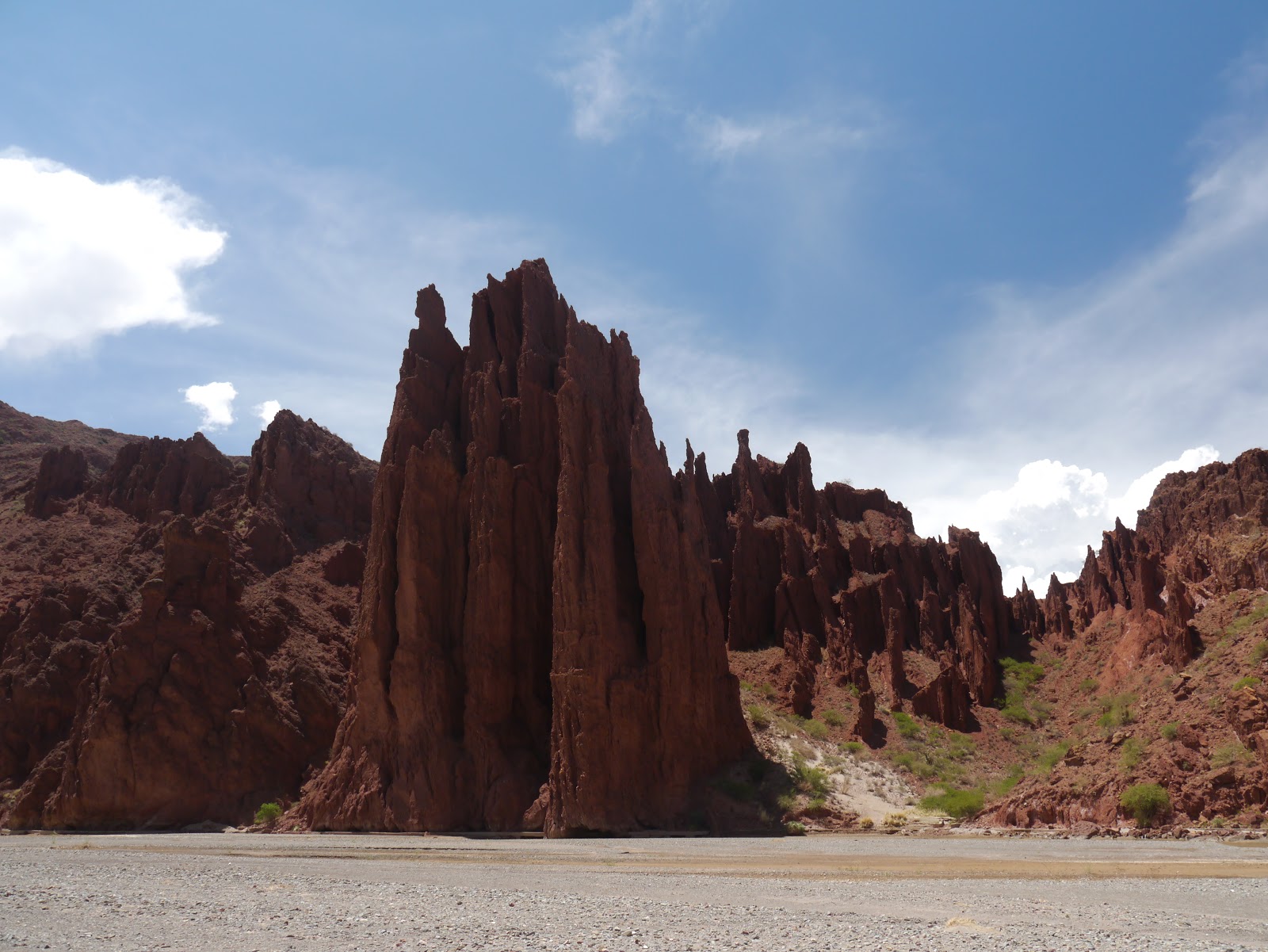
The land in the south of Bolivia and the north of Argentina is ´cowboy country´ with myriads of earth colours, canyons, stony riverbeds and hills carved into unusual pointed shapes and grooves by the rains across millennia. Often, the sedimentary rocks are spread in sandwiches of colours – even within the same hillside, creating a stunning artist´s palette on a grand scale. Tupiza fits this description to a tee and what better way to get into the whole ´cowboy country´ feeling than by going on a two day horse riding tour.

On Horseback:
Tim & Guide Saul En-Route to Los Cañones

Courtesy of my hard working horse, Manty, I explored the river valleys to the south of Tupiza (Roi San Juan del Oro and Rio Tupiza). Another tourist, Juliette from France, and I were guided by Saul. As is the case in much of Bolivia, the children often work during the day and go to school in the evening. So Saul, at only fifteen years old, would sometimes have long days. While this system of working and schooling for the young folk is undoubtedly useful for family economics, I am not sure whether Bolivia is going to match the development of future intellects that may be achieved by other South American countries with more conventional schooling hours.


A Rich Spread of Reds & Browns Inside Los Cañones

Natural Sculptures Inside Los Cañones

During our tour, the first place of interest was Los Cañones which was the first opportunity to get close to the craggy shapes in the red and oxide coloured earth. The ´curtains´ of earth were even taller at the lunch stop by Rio San Juan del Oro at Toroyoj. We continued upstream and crossed the river many times where the flat riverbeds were the perfect place to gallop. I previously had just a few hours of experience of riding and normally would not choose to pass hours on a horse, but soon realised what fun it was with the adrenaline rush of riding a horse at full speed.

´Curtains´ of Rock in Toroyoj by Rio San Juan del Oro

Saul Leads the Way by Rio San Juan del Oro

As we got higher up the valley of Rio San Juan del Oro, the scenery and the breadth of the natural colour palette got better and better. Our accommodation was in the village of Espicaya which is nestled below the cliffs of cream coloured hills. I climbed one of these early the next morning for commanding views of the river valley and surrounding area. While the hills look solid from a distance, they are in fact made up of sedimentary rock filled with stones. The sedimentary rock is in fact so soft it is almost like dry earth. As a result, everything is prone to crumbling and giving way easily – as I found to my cost with a fall, ripping the skin on both legs.


Espicaya Nestled Against the Rocky Hills of
the Rio San Juan del Oro Valley

River Valley Vista from Cerro (Hill) Above Espicaya

In the morning, our return along the valley was made on the other side of the river for alternative views and the chance to get closer to the red coloured hills. There were plenty more high adrenaline moments under gallop. We passed Toroyoj another time and continued along the river past La Torre (The Tower), an aptly named singular rock feature, and soon encountered the railway line which we followed this to pass under Cerro Angosto via a tunnel.


Tim & Juliette in Valley of
Rio San Juan del Oro Near Espicaya

Natural Colour Palette in the Valley of Rio San Juan del Oro

Approaching Cerro Angosto
Along the Railway Line

Valle de los Machos

Before returning to Tupiza there was time to visit Puerta del Diablo (Devil´s Door) – a gap between two rectangular rocks, as well as Valle de los Machos. On the way up to this valley, some clouds were looking a little threatening, but I thought that they would just about skirt past us. Alas not and a brief but dramatic storm ensued with some lightening striking some hills very close by and hail the size of chick peas. That size of hail hurts so we stopped and tried to shelter and to stop the horses freaking out. The sun soon returned and we enjoyed the visual spectacle of Valle de los Machos before heading back to Tupiza.

Tuesday, November 20, 2012

2012, 30th October – 1st November: Sucre & Potosí, Bolivia


For the full complement of photos corresponding to this blog entry, use the following link to the set of photos in my Flickr pages:


Sucre

Of the few cities that I visited in Bolivia, Sucre was by far the most picturesque. Its old district, centred on the main plaza, is a pleasant spread of whitewashed colonial buildings.

Near to the city is Parque Cretácio where earth excavations as part of the production for cement works revealed many dinosaur footprints. Shifts in the earth´s crust tilted, what was previously sedimentary rock from a horizontal muddy plain, near vertically. As such, the footprints now ´climb´ the wall.

Dinosaur Footprints in a Near-Vertical Face

Sucre

Potosí

Potosí, at 4090 metres (13,420 feet) is one of the world´s highest cities. It has a long history of metal mining (since colonial times). Indeed the local mountain Cerro de Potosí is now significantly lower than it used to be, having had so much of its surface removed by open-cast mining. Its interior is now honeycomb like as there are so many mine routes from hundreds of years of ´chasing the mineral veins´ of silver, zinc and tin amongst other metals.

Processing of Silver Ore

The city of Potosí is not a tourist destination in itself as it is not attractive; the main tourist draw is the opportunity to visit working mines that are operating in very basic conditions. My visit coincided with a national holiday so there were few men working the mines – at least that meant that the dust underground was at a manageable level.

Entrance to a Mine in Cerro Potosí
(Those Carts are Pushed, Full of Rock, Manually to the Mine Entrance)

Each of the many mine ´routes´ underground is owned independently or by cooperatives, with many of the miners working freelance.  The result is an apparently unregulated chaotic mix of different mines chasing diminishing resources. Each mineral vein is ´owned´ by whoever gets there first, so at times two different teams of miners can be chasing the same mineral vein (a story by my guide, an ex-miner, illustrated this). Sometimes the two teams can be blasting with dynamite when the neighbouring team is in a separate tunnel just metres away – they better hope that they hear your warning shouts in time.

Tim in a Mine in Cerro Potosí with Plenty of Room to Stand Up
(The Black Hoses Carry Compressed Air to the Drills)

The work is predominantly manual and must be back-breaking; even during my few hours underground the low tunnels started to drive me nuts (mind you I am a lot taller than the average Bolivian). Their drilling is aided by compressed air supplies, other than that all the work is manual, with buckets of excavated material being hauled and lifted up vertical shafts by hand (rarely by electric winch). Once in the ´larger´ tunnels, the carts of rocks are pushed manually along the tracks to the mine entrances.

One of the Carts Which are Pushed Manually
Along Tracks to the Mine Entrance

The majority of the miners suck on a ball of coca leaves to give them the boost necessary to cope with the very tough working conditions. The mines are at an elevation of around 4,200 metres (13,780 feet) and the temperatures underground are in the range of 30 to 40 degrees Celsius (86 to 104 degrees Fahrenheit). If that mix of rarefied air and high temperatures in low tunnels does not get you, then the dust surely will (many miners die by the age of 40 from lung conditions). Given the many dangers present in such conditions, the miners show a great reverence to their god (El Tio).

A Shrine to the Miner´s God - El Tio
in a Mine in Cerro Potosí

Bolivia is a poor country. I believe that the average monthly salary is in the range 2,500 to 3,000 Bolivianos (around £230 to £270 or US$350 to US$410), with the minimum wage being far, far less than this. I understand that the miners make in the region of 3,000 to 3,500 Bolivianos per month, with this rising to 5,000 for a while if they hit a good mineral vein. So really, those poor guys are not really making ´big bucks´ as compensation for the back-breaking work which is literally life-threatening. One miner who was working underground during my visit told me that he was working to save for a car (over a number of years), that is a lot of high-risk work just to save the cash for a car. It is quite apparent that many Bolivians never really manage to get a foothold above the financial level associated with a basic lifestyle; (I avoid using the term ´poverty line´ as I think that poverty has to be judged by more than just your bank balance).

2012, 24th – 29th October: Torotoro National Park, Near Cochabamba, Bolivia


For the full complement of photos corresponding to this blog entry, use the following link to the set of photos in my Flickr pages:


The Torotoro National Park is situated approximately 140 km (88 miles) south of the city of Cochabamba. The countryside around the village of Torotoro is a geologist´s playground with rock formations in many different shapes and colours as well as caves and canyons. Palaeontologists would be similarly entertained by numerous fossils and dinosaur footprints.

The most convenient base for visiting Torotoro is Cochabamba, which is a pleasant city and a far nicer place to spend some time than La Paz. The seven hours by coach from La Paz to Cochambamba is made along the altiplano and through other spectacular scenery. Amazingly, along nearly the whole route of nearly 400 km (250 miles), there was litter scattered along the roadside, and in some of the small towns that I passed the litter was truly terrible. The reason was obvious as the Bolivians on my bus regularly threw it from the window. Sadly, Bolivia is the worst of the South American countries I have visited for litter, with many other visitors noticing it too.

Bus Journey Across the Altiplano - La Paz to Cochabamba
Getting to Torotoro from Cochabamba is a task in itself, with a five hour bus journey each way. The reason for the bus´ high suspension and heavy tread tyres became clear during the bumpy journey through the beautiful countryside on a semi-paved road. A mechanic travelled in the bus as breakdowns seem to be common enough to warrant this. Indeed, during the return journey, our bus broke down and the mechanic and driver spent half an hour getting us moving again.

Bus Breakdown Malarkey: En-Route from Torotoro to Cochabamba
I was fortunate to meet two fellow travellers on the bus to Torotoro – Martin from Germany and Vienna from Hong Kong. I enjoyed their company during tours of Torotoro National Park as well as subsequent destinations in Bolivia.

The National Park

The village of Torotoro is flanked on either side by mountains that are made of amazing semicircular creases in the earth´s crust. Above the town are spectacular views looking down the line of such mountains, like a series of vast waves in the rock.

`Waves´ in the Earth´s Crust Near Torotoro

The High Plain Near to ´Ciudad de Itlas´
On top of the plain at an altitude of around 4,200 metres, the earth and rock is a rich red colour, and we explored its cracks and crevices on the way to Ciudad de Itlas where a series of natural arches and columns create a small natural feature reminiscent of the slender columns and curved arches in gothic church architecture. Later in the day we walked and scrambled in the Humajalanta cave. The spectacle was marred a little by the fact that every reachable stalactite and stalagmite had been snapped off as a souvenir. Deep in the cave is a pool where some tiny blind fish live, having adapted to the complete darkness. Their blind state was clear as they did not respond to the presence of our head lanterns shining on them.

´Ciudad de Itlas´

Rock Detail - ´Ciuadad de Itlas´
The next day we made a tour that included many dinosaur footprints and the Torotoro canyon. At various locations in the valleys around Torotoro are places where sedimentary rock has been lifted to the surface or exposed by the action of a river. Here one can see the progression of huge beasts as they walked across a muddy plain. Some of the footprints are very large and in places there is a long line of footprints of a lumbering herbivore.

A Fossilised Dinosaur Footprint
(With My Boot There to Show How Big it is)

An Inverted Fossilised Dinosaur Footprint
The view of the Torotoro canyon from above is spectacular, but the experience is even richer when one walks and scrambles around and over the creamy red rocks and boulders at its base, with the high canyon walls and greenery far above. After stopping at the El Vergel waterfalls, we made our way to one of the lesser visited upstream sections where the canyon became thinner and more beautiful as we headed towards a great swimming spot. During the wet season, water plunges from the start of the canyon high in the plains above – things where more tranquil during my towards the end of the dry season. I swam in the thin stretch of (very cold) water only a few metres wide between high vertical walls of rock before warming up in the afternoon sun. We then climbed to the top of the canyon and headed across the valley to the village to finish a great day.

The Torotoro Canyon Viewed from Above

Following the River Course in the Torotoro Canyon

Lying Down & Looking Skyward from the Floor of the Torotoro Canyon

Red Earth, Red Sky Near Torotoro

Moonrise Near Torotoro
The village of Torotoro and the national park by the same name is a relaxing place to be and the countryside is both spectacular and beautiful. I would have happily spent more time there, but as I am in the latter stages of my travels, time is becoming a diminishing commodity with many places to visit remaining on my wish list.

Tuesday, October 30, 2012

2012, 13th – 23rd October: La Paz & Environs, Bolivia

For the full complement of photos corresponding to this blog entry, use the following link to the set of photos in my Flickr pages:


My time in La Paz and its environs was an opportunity to spend some time with that someone special from Medellín and explore the area with her, using La Paz as a base.

La Paz – The City

I was not taken with La Paz. It is a chaotic mix of steep and dirty streets and terrible traffic fumes. Passages of vehicles and pedestrians are constantly slowed by the innumerable stalls set up in the inside lanes of the streets. Streets are poorly lit at night (giving the place a grungy feel) and there is little to say about the place architecturally. Hence, we got out to the countryside as much as possible which is where the charms lie. The three excursions we made were a day on ´La Carratera de la Muerte´ (´The Death Road´), a two day trip to the Sajama National Park and a three day trip to Lake Titicaca (including Copacabana and Isla del Sol).

View of the Steep Sides of La Paz From Hotel Window

´La Carratera de la Muerte´ (´The Death Road´)

Until around six years ago, there was only one route from Yolosa and Coroico to La Paz along a precarious gravel mountain road. For the vast majority of this crash barrier-free route, one´s options for manoeuvring were limited by the wall of the cliff on one side and the drop of the cliff on the other. Those descending had the roughest deal as the obligation was that those travelling downhill were to take the outside (drop side) lane. With the extent of the road being frequently little more than the width of a vehicle, passing oncoming traffic would have been a death-defying challenge – even at the wider passing points. Often drivers did not do a particularly good job of the death-defying bit and they (and any passengers) met their maker at the bottom of the cliff. In fact, it is reported that the road used to be responsible for several hundred deaths a year. With such statistics, the ´death road´ name was apt in the days it was the principal vehicular route.

´La Carratera de la Muerte´ Tracking down the Valley

The following web page gives a very good personal account of the harrowing history of the road when it was used extensively by vehicles:


Around six years ago the crazy road was replaced by a modern alternative in the next valley; and now the death road is predominantly a tourist´s playground. We joined one of the numerous agencies offering an exciting day to descend a total of 3,500 metres / 11,483 feet in altitude (from 4,700 to 1,200 metres) along a distance of 63 km (39 miles). With such an incredible height change, one feels like one visits two countries in four hours as the change in temperature is remarkable. Since it is all downhill, one can ride 63 km virtually without pedalling, so even circumferentially challenged people could enjoy the day.

The Precarious Death Road
Since a man on a bike is not very wide and pretty much everyone on the road these days are tourists travelling in the same direction, the death road tag is now predominantly tourist industry hype as, in my opinion, there is no great risk. Reportedly some cyclists do project themselves towards the valley floor, but I suspect that they might have forgotten that excessively fast cornering, gravel and a cliff edge are a bad mix. As long as you do not go at too crazy a speed, it is all relatively gentile.

Sajama National Park

As my last blog entry on Arequipa, Perú attests, I am a fan of the intoxicating blend of landscape, light and colours of the altiplano (high plain). One volcano-scattered part accessible from La Paz via a two day trip is the Sajama National Park. It is named after Volcán Sajama (the highest peak in Bolivia) and lies next to the frontier with Chile.

Upon leaving the centre of La Paz which lies in the valley floor at around 3,600 metres (11,811 feet), one climbs to El Plano at around 4,000 metres (13,123 feet). From there, the journey across the altiplano is eventful as there are many visual niceties worthy of a photo stop. These include red and yellow rock strata upended by shifts in the earth´s crust as well as vistas with wide planes and vast skies.

Altiplano View En-Route to Sajama

Rock Forms En-Route to Sajama
with Volcán Sajama in the Distance
 
The Sajama National Park is spectacular and while staying in the remote pueblito (village) of Sajama, the immediate plain is ringed by the snow-topped peaks of Volcánes Sajama, Anallajachi, Pomerape, Parinacota and Acotango, which draw one´s eyes skyward to the azure canvas flecked with sunlight-stratifying clouds. Though the volcanoes are now inactive, the fissures in the earth´s crust are evidenced by the mineral deposits on the surface of the ground and the geysers. In many places the earth is turned white by the natural saltpetre (potassium nitrate) deposits. Near to the pueblito are geysers (no dramatic skyward gushes just bubbling), and thermal baths where one can enjoy a hot open-air bath with views of snow-capped volcanoes.

Volcán Sajama

Volcánes Parinacota & Pomerape

Geyser Near Sajama

Tim Enjoying the Thermal Baths
with Volcán Sajama in the Distance
Near to Sajama village there were plenty of opportunities to see llamas and alpacas, (alpacas are a shorter more-furry cousin of the llama). Alpacas ´son muy bacanas´ (are very cool). We were highly entertained and amused by the way they happily look at you with their fur-ringed faces. They seem to consider you for a moment as if you are vaguely familiar to them, like they know you from some time back, but do not have the time to stop and say hello as there is just so much grass to be eaten.

Alan Alpaca

Alpacas ´Recognizing Us´ with Volcán Sajama in the Distance

Lago Titicaca

Would Lake Titicaca be quite so famous were it not for the rather cool and memorable name – who knows? Straddling the border between Perú and Bolivia, it is certainly large at around 165 km (103 miles) long and 280 metres (919 feet) deep. The town of Copacabana is the main launching pad for exploring the lake on the Bolivian side. For a town centred round tourism, Copacabana is not too bad and is not gratuitously touristy.

Lago Titicaca: En-Route to Isla del Sol
For a more peaceful connection with the lake we travelled the 1½ hours by boat to the south of Isla del Sol (Sun Island). The views from the top of the ridge that runs the length of the island are beautiful. Viewed from above in the bright high altitude sunlight, the blue of the lake is intense and is set wonderfully against the sun-baked earth colours of the island and the nearby mainland. I can appreciate why the island was the birthplace of the Inca Empire as it is an inspiring place.

View from Isla del Sol with the Snow-Capped
Cordillera Oriental of the Andes in the Far Distance

Elevated View from Isla del Sol


Friday, October 19, 2012

2012, 8th – 12th October: Arequipa, Perú

For the full complement of photos corresponding to this blog entry, use the following link to the set of photos in my Flickr pages:


The City

An unmistakable feature of Arequipa is its volcanic context. From much of the city one can see the peaks of (volcanoes) Volcánes Chachani and El Misti - the latter having the classic cone shaped form. Furthermore, many of the buildings, particularly in the historic centre, are constructed in the volcanic stone, sillar. Sillar has a creamy pale grey colour with numerous voids – evidence of the explosive nature of its creation. The sillar stone is responsible for much of the architectural charm of the city. In case any inhabitants of the city forget that those picturesque peaks were created by the transient nature of the earth deep below us, it is rocked by earthquakes at times - sometimes strong enough to do real damage.

Arequipa Catherdral in Plaza del Almas

Unsurprising, the centre point of the city is the Plaza del Armas (pretty much every Peruvian conurbation I have visited has a square / plaza by this name). Notable buildings blessed by the aesthetic charms of sillar are the cathedral, Inglesia de la Compañía, Claustro de la Compañía and Monasterio Santa Catalina. Many, such as Claustro de la Compañía, contain courtyards ringed by beautiful columns with artistic features carved in the sillar. Monasterio Santa Catalina is a walled village within the city. Its hidden streets were built to give nuns a very quiet and contemplative life completely isolated from the outside world. The majority of the site is now open to the public, though walking around it does become rather repetitive as most of it is comprised of many individual nun´s dwellings which are all very similar.

Reflections in a Cafe Window with
Inglesia de la Compañía Outside

Arequipa Catherdral in Plaza del Almas

Claustro de la Compañía
Sillar Columns in Claustro de la Compañía


Laguna de Salinas

Laguna de Salinas is a salt flat / lake located at an elevation of 4,250 metres (13,943 feet) - nearly 2,000 metres higher than Arequipa. It is reached via a long winding unpaved mountain road that interestingly used to be the principal route between the cities of Arequipa and Puno – fortunately a few days later I could make this journey via the modern paved alternative!

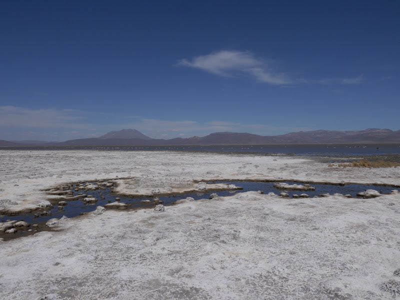
I was given a tour by a very friendly local guide, Julio. The laguna is flanked by Volcánes Misti and Pichu Pichu, which together with the intense blue skies and clear light at such altitudes provide a spectacular setting. Normally at the end of the dry season, the water at Laguna de Salinas has evaporated. However, the rains were heavier than usual during the last wet season, so while I was there the salt was only visible at the edges. However, the presence of water meant that there were many flamingos feeding in the shallow lake.


The Amazing Colours of the Altiplano
at Laguna de Salinas

Volcán Pichu Pichu from Laguna de Salinas

This was my first taste of the nature of the altiplano (high plain) that lies on the spine of the Andes from southern Perú down through Bolivia and into the north of Chile and Argentina. The environment at Laguna de Salinas provided the slightly other worldly feeling that I was hoping to experience. The winds and challenging environment at such altitudes mean that there is no vegetation other than grasses and scrub like plants; as such it has a desolate air, however, there is much beauty in this wilderness. The intensity of the blue cast by a sky, which has a greater purity being that bit closer to the heavens, unifies the tones of the wide colour palette – from the earthy reds, browns and greys of the volcanoes on the horizon, to the green-grey water of the laguna and its dusty white borders of salt.


The Salt-Laden Earth at the Edge of Laguna de Salinas

Flamingos Feeding in Laguna de Salinas

Onwards to La Paz, Bolivia

After over two months in Perú, of which one month was dedicated to all those mountain ascents in the Cordillera Blanca, it was about time I headed to my next country, Bolivia. The first leg of this journey involved the bus climbing up from Arequipa past volcanoes to the altiplano. The views were splendid with azure skies above earthy yellow grasslands spreading to views of Volcán Misti in the distance.

After a quick pit-stop in Puno I changed buses to cross the frontier to Copocabana which is the first Bolivian town across the border (it is on the shores of Lago Titicaca). The third bus of my journey then set off to La Paz. Part way through this route it is necessary to cross a thin section of Lago Titicaca. We were told to get off and make this crossing separate from the bus in small wooden boats. The reason for our crossing being on a different vessel to the bus became clear. The bus was transported on a barge that was so low it looked like the bus was being floated across on a couple of planks. That all looked rather top-heavy – hence a good idea for the passengers to be on a vessel with a higher centre of gravity (I wonder if there are any buses at the bottom of the lake).